Happy Jack
Well-Known Member
- Joined
- June 5, 2004
- Messages
- 739
- Reaction score
- 4
- City, State
- Wichita, KS
- Year, Model & Trim Level
- 94 Sport
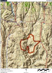
Green River was once home for a missile test site. If you have time it's a great place to poke around and kill some time.
http://www.youtube.com/watch?v=Vs8S26MrR5A
My pics are of the geyser and the bunker.
http://www.youtube.com/watch?v=Vs8S26MrR5A
My pics are of the geyser and the bunker.


 Yeah Ted some great memories of the "1st annual Desert Expedition" and I will be making another one for the 2nd and on and on... I hope. It will be great to wheel and stop and camp, hang out, take photos and just yak, oh.... and cook.. Scott do you hear me?