Anyone in St. George? | Page 3 | Ford Explorer Forums - Serious Explorations

  • Register Today It's free!

Anyone in St. George?


Join the Elite Explorers for $20 each year.
Elite Explorer members see no advertisements, no banner ads, no double underlined links,.
Add an avatar, upload photo attachments, and more!
.


turtle.jpg


Ahem, sorry, i meant if i turtle...


I'm looking to do a couple of weeks out that way in the fall. I've been looking for some info and don't know if anyone in St. George would be able to help or not. Most of my time would be in Arizona.

There are a half dozen or so things in the area that folks want to do. some want to do the North Rim of the Grand Canyon. That is not open now. I had the same problem when we went there in the past. So we moved this to the fall when the North Rim is open. The idea was to go in or come out through the Kaibab NF back roads.

We could start in Page, AZ. Some wanted to go look around SW of Page at Lee's Ferry. That was the start for the Honeymoon trail that went to St. George. http://honeymoontrail.smugmug.com/gallery/2876745/1/154469507 Don't know if we could find enough of that old trail for us to follow and to do a write up on or not. From St. George there was the Temple Trail that went down to Mt. Turmbull where they cut tembers for the temple in St. George. http://www.coloradoriverinfo.com/arizonastrip/temple.trail.shtml Don't know if we can find enough of that trail for us to follow and to write about either. At Mt. Trumbull there is a hike to some rock art. http://www.blm.gov/az/st/en/prog/recreation/cultural/asfo_cultural/nampaweap.html From there we could go down to Toroweep. http://www.arizonahandbook.com/toroweap.htm Then back north to Kanab and maybe a side trip to Hack Canyon. http://www.loupiote.com/photos/18425438.shtml From Kanab south into the NF backroads to Point Sublime and on to the North Rim. Then back on the highway to Kanab to re-supply then back down to Mt. Trumbull and on SW to Ft. Garrett. Scroll down to page 26 on this link to read about Ft. Garrett. http://www.grandcanyon.org/booksmore/epubs/pillar/pdfs/chapter3_part1.pdf They closed the road several miles before Ft. Garrett since I was there. From there north to Mesquite, NV.

I have a side trip I'd really like to do. West of Page, AZ 26 miles on highway 89 is Cottonwood Canyon Rd. North on that road a short distance is a loop to the east that connects back to Cottonwond Canyon Rd. I want to do that loop again and would like to see if I could get someone to take a picture of my truck as it drops back down to connect to the main road.

If anyone has info on the Honeymoon or Temple trails please let me know. The group I travel with will camp out in the desert most every night. We live out of our trucks and use towns to resupply and get a shower every now and then.


...Depending on the economy and my funds at the time, I may be interested in joining you guys on the trails if not all but at least part of the journey...


No trouble on this end. Thing is we are retired and change stuff up a lot. Been trying to get a spark lit for them on those trails. I figure they are mostly graded dirt roads. There is a little rocky canyon north of Ft. Garrett in the AZ strip that we climbed last time. Not sure we can find it again. That side trip off of Cottonwood Canyon Rd. has a little climb out of Coyote wash that is fun. That takes you up to Brigham Plains. But the view down onto Cottowood Canyon Rd. at Hackberry is wondress.

If we do this it would be for stock 4x4's. That treck from Knab to Mosquite my require extra fuel. I have the std. 19 gal. tank in my EX and an auxl. tank that I can get 12.5 additional gal. of fuel out of. They recomend you carry extra fuel and 2 spare tires.

The dates can be troublesome. We started planning this last October and had it planned for april and moved it to the fall. We planned a HITR trip for april in it's place and that has been moved 3 times. HITR is now planned to start in the San Juans Memorial Day weekend and then go on over to Utah after that. Our motto is one day at a time. No telling what the next two weeks will bring.

I'm just having trouble finding a lot of information on the Honeymoon and Temple trails. The more info I can find the more likely I will be to lite that spark to get folks out. There has been mention of an august trip back to the San Juans for Stony Pass. Also of a september trip from Castlegate down to Robbers Roost and back up to Browns Hole and on up into Wyoming. North Rim is penciled in for Labor Day weekend. Those all might be tied together. Have ta see what makes the cut if there is one.

If I'm gonna be in the area and if other folks want to do some of this I'll do my best to join up. I can always go out early or stay late. Within reason that is.


Hey you got my interest! just keep us up to date on this....Vegas is close to ST George!


Also check out Utah 4X4. They have a bunch on there, they did a run to mt. trumble a few weeks ago. We are going to do a drive out to Toroweep memorial day weekend. On that Monday.


Thanks for the help. I was kind of looking for a detailed map with land marks and maybe a journal by some one who made the trips with info on stops and land marks.

We'll be looking to follow as much as the original trail as we can. Some times these things don't work out. The Reservation covers most of the area south and east of Lee's Ferry. And there is Wilderness closed to motorized travel to the west. And private property can cause problems. I'll check the links this summer to see if I can find more but if anyone knows of a book or a journal or old maps or many times folks who run museums have that info please post up.

Toroweep is kind o cool. As I remember the that is supposed to be one or the only place you can view the bottom of the canyon from the rim. We camped down there a couple of times. Been 10 year or so though. And Mt. Trumbull is a nice drive. Last time I was there at the old township (also called Mt. Trumbull) west of the mountian at the cross roads that had an old school or church that was being restored. We went in one time.

We tried twice to get from that building/crossroads to Fort Garrett. The first tiem we ran into a no tresspass sign on a gate. Fould out later we could go through we just weren't suppose to leave the road or stop in that section till we made it to another gate. So the first time we went around and were going to loop to the north. But indians attacked and one guy had a flat. We changed it and headed for St. George. Seems a arrowhead caused the tire damage. The next time we got through and a buch closer when I had fron wheel bearing trouble. We turned around and headed north toward St. George again. The bearing didn't last and I had to ride with a friend into town for parts and replace them out in the strip at an old cattle pen. We were headed out to Nevada for a deal and went on out there. On the way back we ran the treck in reverse. We left Mesquite and camped in the mountians southest of there at a notch at the top. Then we made it all the way to Fort Garrett and back out to Kanab.

I always wanted to go back and do it east to west just one time.


I have a Projects Folder in Delormes Topo 6.0 with what I have so far. If anyone is running 6.0 or newer I can e-mail it to you. And I have a few pic's of my last trip from Mesquite, NV to Fort Garrett.


I've been working on this. Pulled out some oldie software. Delormes Topo Quads circa 1999. I have found much of the Honeymoon trail from Lee's Ferry SW of Page to St. George. And I have a good idea where the Temple Trail went but only a little over 1/2 locked down solid. Thinking about maybe mid September. Most likely not going to be a North Rime trip. Might just be the Temple and Honeymoon trails with some time around Vermillion Cliffs.


Still interested. I need to pay more attention to this post!


The main guy that wanted to do this is most likely out. He wanted to do the north rim so I don't plan to do that. I have one guy who still wants to do this and the Vermillion area. Says there are warnings about soft sand in that area and needs others to go in with him. Most likely I'll pre run the Honeymoom and Temple Trails and get some tracks mapped of where roads really are. And I'll let the other guy handle the Vermillion area. He does want to do a treck across the Strip. So that may happen too. Not sure what else. Might be out west next week for a few weeks and up north in August some time. So I'll do more the closer we get and see how many folks we have. Still looking at September 11th through the 19th as target dates but that may change some.


Well the 11th and 12th I will be working :-( but I will keep an eye on it!


Gettin close and I just kinda have a general schedule right now. Trucks in the shop as I was in Colorado last month and it ran really hot going up long steep climbs and on the highway at 70mph in 103 degree weather. If it gets fixxed then I may go out for the Colorado Colors run Sept. 3rd through the 6th. Then I may meet a guy on the 9th in Alamosa, CO on the 9th and spend 5 days going south with him to the border. Then up to Jacobs Lake area to meet a guy for the Honeymoon and Temple Trails along with some other stuff starting the 15th. I have to head for home on the 26th. When I get the rest of it nailed down I'll post.


There are way better trails than the honeymoon and temple trails here. West Rim trails is my favorite and has something for everybody. Or depending on what your rigs are there are guys here that can take you to anything you want to do. From Sand Dunes to Slick Rock to Guaranteed body damage trails! :)
Hit me up if you want more info and things here. I live here in St. George.


Thanks! Do you have a source(s) on the Temple Trail? I called the BLM in St. George and they are going to get a book for me on the Honeymoon trail but didn't have anything on the Temple trail. Anything would help. I have read there was a summer and winter route. A contact person would be great. We will, I hope, come back sometime soon I hope but I'd like as much info to check out this trip as possible.

The purpose of this is to pre run the area for a friend of mine Larry. Larry and I were trying to arrange trips for this year last winter and tried to schedule this trip for the spring. But he wanted to do a lot of other stuff including the North Rim and it didn't open in time. So we moved this to the fall and scheduled a Utah trip that got washed out many times and another friend of ours Neil was not able to make it. I broke a lifter on the way out near Hanksville and Utah trip was mostly a wash. Larry did some other stuff in Utah and we went to the San Juans last month and started working our way south. Larry wants to continue the south treck in September and we'll see if he is able to or not. But he is not ready for the Arizonia trip. Neil really wants to do this though after being shut out of the spring trip several times. Another friend Bob is going to joi us. So we have three folks right now.

Looks like we will start on the evening of the 14th or the morning of the 15th at Lee's Ferry SW of Page. Then follow the Honeymoon trail to St. George. We will have a side trip into the Vermillion Cliffs National Monument. From St. George we'll follow the Temple Trail down to Mt. Trumbull. Then a side trip down to the Toroweep area. I need to follow these trails and map out where the roads really are and take a few photos. Most of this will be doing stuff Neil has planed. But he will be leaving on the 22nd to head home. I can stay out till the 26th if folks want to gtg for something.

If anyone would like to join us let me know and send me a PM or e-mail and I'll get you my cell number.


Yeah for sure. I have been out to Toroweap a few times and is well worth the 200 miles of washboard road. Mt Trumble isn't to far off that road. That really isn't a temple trail anymore its a road that goes between the two and loops back to Colorado city to. As far as the honeymoon trail from more or less page to St. George, it actually goes into Hurricane I believe, I have never been on that road.

If you guys want some rock crawling on slick rock or sand dunes I know just where to go. That's where I spend most of my time on my quads and truck. My brother has a 91' that can come out to. The web site to get info is the utah4X4 forum. Utah4X4

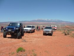
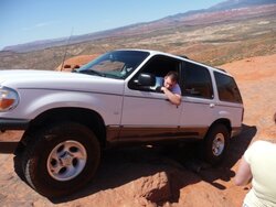
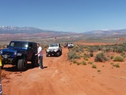
You have to pay the the bucks to get full topos of the trails because they had some vandal problems with people that aren't willing to take care of the area we work hard to keep open so that's the reason for that. But I can get you a topo of the West rim trail (not grand canyon trail in anyway, as to not get you confused) its slick rock and sand here in St. George. Its only bettered by Moab as far as big awesome obstacles to trails for fulls size pickups. I can post some pics of the west rim here in St. George to. I'll do it in the next few posts.


Join the Elite Explorers for $20 each year.
Elite Explorer members see no advertisements, no banner ads, no double underlined links,.
Add an avatar, upload photo attachments, and more!
.


This is the West Rim Trail. And there are WAY bigger things to go over if you wish! So that almost guarantee a :roll:
 

Attachments

  • P1020381.JPG
    P1020381.JPG
    110.5 KB · Views: 116
  • P1020388.JPG
    P1020388.JPG
    117.9 KB · Views: 121
  • P1020394.JPG
    P1020394.JPG
    103.7 KB · Views: 120
  • P1020401.JPG
    P1020401.JPG
    113.8 KB · Views: 112


Back
Top