2TimingTom
Elite Explorer
- Joined
- October 12, 2010
- Messages
- 2,503
- Reaction score
- 110
- Location
- Littleton, CO
- City, State
- Littleton, Colorado
- Year, Model & Trim Level
- '97 XLT
On Sunday 8/12/2012 I hit the trails with a buddy from work. We started up above the small mountain town of Alice and worked our way over to Rollins Pass.
Here is Alice seen from the trail:

I need a new bumper........


This tree was interesting. It looked very wind blown. The bark on one side was missing:


Near the summit of the trail is a rock cairn house that has grown over the years. We remembered to grab a rock from further down the mountain. It's considered good luck to either bring a new rock or move a rock in the pile.


There is a lake below here that I'd like to go check out some other time called Loch Lomond:

The temp at the cairn house was:

It felt great in shorts and a t-shirt.


This Ranger was parked out in the middle of the tundra:


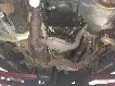
This section of the trail was the most difficult of the day. It just had some large rocks that needed attention. I came down on a rock and thought my new sliders had just paid for themselves- but instead I hit the torsion bar mount:


At the bottom of this section was a parking area that is easily accessed from a shelf road to the right.


At the upper end of this valley is the Moffat Tunnel which was built in 1923 and still used by the RR today:


The tracks ended right behind where I was parked:


Up near the top of Rollins Pass is Yankee Doodle Lake (yes, the white thing is snow):


An old mine shaft:


The Needle Eye Tunnel can be seen here. The Moffat Tunnel made this tunnel obsolete:

You use to be able to drive through the tunnel after they tore out the RR tracks. But the tunnel caved in a couple times so they closed it. You can go up both sides of the pass though.


The flat part of the mountain off in the distance is where the Kingston Peak trail was at.


We had lots of fun and racked up a bunch of miles on dirt.
Here is Alice seen from the trail:
I need a new bumper........
This tree was interesting. It looked very wind blown. The bark on one side was missing:
Near the summit of the trail is a rock cairn house that has grown over the years. We remembered to grab a rock from further down the mountain. It's considered good luck to either bring a new rock or move a rock in the pile.
There is a lake below here that I'd like to go check out some other time called Loch Lomond:
The temp at the cairn house was:
It felt great in shorts and a t-shirt.
This Ranger was parked out in the middle of the tundra:
This section of the trail was the most difficult of the day. It just had some large rocks that needed attention. I came down on a rock and thought my new sliders had just paid for themselves- but instead I hit the torsion bar mount:
At the bottom of this section was a parking area that is easily accessed from a shelf road to the right.
At the upper end of this valley is the Moffat Tunnel which was built in 1923 and still used by the RR today:
The tracks ended right behind where I was parked:
Up near the top of Rollins Pass is Yankee Doodle Lake (yes, the white thing is snow):
An old mine shaft:
The Needle Eye Tunnel can be seen here. The Moffat Tunnel made this tunnel obsolete:
You use to be able to drive through the tunnel after they tore out the RR tracks. But the tunnel caved in a couple times so they closed it. You can go up both sides of the pass though.
The flat part of the mountain off in the distance is where the Kingston Peak trail was at.
We had lots of fun and racked up a bunch of miles on dirt.
 Exploring old mines and mining towns is the best