Official Moab to Monument Valley 2012 trip report | Page 2 | Ford Explorer Forums - Serious Explorations

  • Register Today It's free!

Official Moab to Monument Valley 2012 trip report

just a few for now to add on to Tbars post. Me out on musselman arch, its about 4'-6' wide! Some of the rim/cliff driving and scenery. White Rim was awesome, finally glad I did it.
 

Attachments

  • m_DSC02907.jpg
    m_DSC02907.jpg
    150.4 KB · Views: 619
  • m_DSC02916.jpg
    m_DSC02916.jpg
    118.8 KB · Views: 594
  • m_DSC02924.jpg
    m_DSC02924.jpg
    94.2 KB · Views: 604


Join the Elite Explorers for $20 each year.
Elite Explorer members see no advertisements, no banner ads, no double underlined links,.
Add an avatar, upload photo attachments, and more!
.


The one where you can drive up to the edge of the dry water fall always scared me. It would be so easy to just drive right off of it, especially at night. It looks like the drop is about a mile also.

The photo of Musselman Arch reminds me of when I took a picture of my wife on it. She told me to specifically not let her get over the unsupported area. I kept coaxing her to move farther and finally took the picture. When she saw the picture after we got the film developed, she got very angry with me.

I am just about ready to begin my near all night trek on Sunday to meet up with you guys.


Love the pics!!!!


Great pics! Keep'em comin':chug:


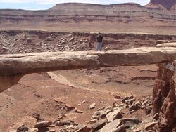
..We camped out in a canyon northwest of Arches last night...Today we ran around Arches and we are now at the visitors center by Moab...

..We started this morning off with Scott leading and the first trail we get to you hear over the radio, "Oh Hell No!"..:D

..Needless to say we didn't take it because Mikes truck would have had to been drug and the rock holes were to deep..:scratch:..and Scott didn't want to risk scratching his truck..:shifty_ey ..yet.

Couple updates though..

..Temps are in the 80's day, 50's night now..

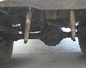
..Brian has a hole in his airline just outside of the tank and it will need some wrenching to repair..

..Scott either still has the partying mouse in his Ranger or he picked up a new one last nite...

..Martin lost all power to his Toyota and we believe it is a corroded post and scan gauge combination problem which we remedied quite quickly..;)

..The owners have tested their own showers but not much speak on their reviews yet..:dunno:

..When I get more time and a plug in somewhere I'll post more pics, some rather interesting news, and possibly some GoPro videos of mine...

..Stay tuned..:popcorn:


BTW we need help identifying a lifted blue first gen X with dark tinted windows..He looked as surprised as us to see our trucks going the other way but we are hoping he will pop in here and say hey..

..Edit:

..While I'm sitting in the Parking lot and the rest of the crew ws coming out of the visitor center, some yahoo hit Scott's dad's truck in the mirror in front of all of us..:rolleyes:


...The group split up shortly after yesterdays post from the visitor center...:burnout:

..Martin, Mike and Scott decided to head back to the previous nights campsite area northwest of Arches NP so they could revisit Arches due to the heavy tourism weekend while Brian, Myself, and Scott's Dad headed south of Moab to camp and offroad explore locally..

..We are all meeting up today in Moab again to fuel and stock up then head south toward Monticello tonight to find a camp then meet up with Red_FX4 tomorrow a.m..

..Will post pics shortly and possibly a video..;)


Sunrise at Labyrinth camp, White Rim.
Passing under the fallen rock on Long Canyon.
Hoping the curb near Delicate Arch in Arches NP to start a trail
Harley taking in the view on top of Hurrah pass today
 

Attachments

  • m_DSC03025.jpg
    m_DSC03025.jpg
    27.1 KB · Views: 532
  • m_DSC03037.jpg
    m_DSC03037.jpg
    83.9 KB · Views: 513
  • m_DSC03061.jpg
    m_DSC03061.jpg
    78.6 KB · Views: 547
  • m_DSC03084.jpg
    m_DSC03084.jpg
    126.3 KB · Views: 583


Our split group today on top of Hurrah Pass with a view looking North-ish. Behind is a view of the Colorado river.

Tbars' Moab carwash through Kane Creek on the way to town from Hurrah Pass.
 

Attachments

  • m_DSC03086.jpg
    m_DSC03086.jpg
    89.9 KB · Views: 538
  • m_DSC03090.jpg
    m_DSC03090.jpg
    157.9 KB · Views: 543


..Live..Brian and his dad Jim watching tv at Mcdonalds while I slave on the computer behind them..:D
P10100215.JPG


..A shot from the rear of the group...:mattmoon:
P10100106.JPG


..This is Jamie from Telluride and his dog Tupelo Honey who graciously shared his campsite with us on this busy weekend and it was his dog's first camping trip..:biggthump

jamie.JPG


...I call this one the two Dad's..This is Brian and Scott's Dad on top of Hoorah pass with Binoculars looking across the river and the great expanse..
dads.JPG


..Now our trip into and out of the Kane creek camping area let us see 3 different accidents in the brief time we were there...

..First we followed an ambulance and EMS to right before we camped...An older Chevy truck with shell had just rolled over to the good side of the road but it looks like driver was ok but the truck looked like it had the motor pushed in at the front from a big rock..(No pic)

...Coming back from the top of Hoorah this a.m. some motorcycle guys asked us if we saw the quad accident..On the way down a couple hundred feet or so and knowing the general location we spotted it..It is dead center bottom of this pic...Sorry it was a ways off but we could see the fuel leaking, the seat and what looks like a camel pack about 50 ft. above but no body so we hoped this was a earlier rescue of the day before..
P10100146.JPG


..Another not so good picture but we arrived shortly after this guy rolled on the "Z" turn at the beginning/end of Moab Rim trail..The roof of one of the two jeeps is facing us..
P10100209.JPG


..Some really important info when in the area...Where to get showers and wifi service w/ computers..;)

0421121106.jpg


0421121106a.jpg


..Update: This just in...:eek:

Disclaimer:..First let me say, I wasn't on the same road or trail and I don't even think I was within 100 miles of the incident..:shifty_ey

...I just saw Scott's truck drive into City Market and I would say he scratched it but good (easily fixable from my viewpoint) but rumor has it it could have easily been a lot worse..

..I heard he's not in a talkative mood so we will post up when we get the low down in the next day or so..

..In other news...Brians invertor is now on the fritz and he is using mine which only works in his truck..:confused:
..Stay tuned..:popcorn:


Great reports!

Makes me jealous :(


Looks like some awesome scenery:thumbsup:


..I believe Martin as well as Brian are already home..

..I made it home around 7 am this morning..

..I would have made it directly home by 2 am but high winds, rain, zero visibility on Cajon pass had turned over semis and I already had my hands full keeping my rig on the highway with this weather..

..I got a couple hours shut eye up in Victorville at a truck stop which I took full advantage of their showers and left a few pounds of Utah red behind..:D

..I have a bunch of stuff I need to deal with but I will get pics and videos up slowly but surely..

..Oh yea...Scott's dad and I stopped in and saw the "Code Talkers" exhibit on the way home..:biggthump


I just went through my 400-ish photos and selected 36 to upload.

Getting caught up, Monday around noon we started going up the mountain outside of Monticello where we were stopped dead in our tracks by 1' of snow on the road. We could have made it but it would have taken alot of work to get our whole group through.

m_DSC03092.jpg


We turned around and took the highway to Comb Ridge and dropped in from the North and headed South in Comb Wash. We got to the other highway after ~25 miles and proceeded to South Comb Wash with River House Ruins as the destination. First Mormon Immigrant Trail sign post was spotted near the ruins.

m_DSC03109.jpg


The Rincone Ruins ("The corner") near the San Juan River used in the 1880s

m_DSC03114.jpg


We made camp nearby and then walked the .4 miles to the Riverhouse Ruins the next morning. These ruins were abandoned around 1200. It consisted of 2 houses and a circular room in the middle for religious purposes. A little ways away was their Granary where they stored their corn, beans and grain.

m_DSC03135.jpg


m_DSC03164.jpg


Some pottery, tools and 800 year old corn cobs

m_DSC03138.jpg


m_DSC03161.jpg


Join the Elite Explorers for $20 each year.
Elite Explorer members see no advertisements, no banner ads, no double underlined links,.
Add an avatar, upload photo attachments, and more!
.


From there we went back out and through the highway cut on the South side of Comb Ridge and started North up Butler Wash. Butler is on the high side of the Comb. Our first stop was Wolfman Pannel where after a short hike and scramble down some ledges you come to the Wolfman

m_DSC03187.jpg


On the hike back TBars and I spotted this cool lizard

m_DSC03197.jpg


Leaving there we made another turn on a spur road to the Monarch Cave Trailhead where we hiked another 3/4 mile to the top of a canyon where there was more ruins.

m_DSC03205.jpg


The cave is below a natural pour where water runs off the top and into a pool below providing a source of water. Along the trail up to the ruins were more pottery pieces.

m_DSC03208.jpg


Inside was a stone they used to grind up their grains

m_DSC03223.jpg


Shot from inside looking at the trail along the edge

m_DSC03226.jpg


We then hiked back and had lunch. Continuing North we saw Fishmouth cave but due to time we did not stop to hike it

m_DSC03243.jpg


We aired up at Butler Wash Ruins pullout and I made the hike to see the ruins

m_DSC03250.jpg


We made one more stop at another roadside ruin and then went to Muley Point which happens to be one of my favorite places in Utah. This is looking towards Monument Valley

m_DSC03268.jpg


John's Canyon Trail -we will save this trail run for another time

m_DSC03272.jpg


The Goosenecks from Muley Point

m_DSC03274.jpg


Sunset Tuesday night

m_DSC03278.jpg


Back
Top